INTERPRETATION OF PHYSICAL AND CULTURAL FEATURES ON A MAP
CONTENT
- Interpretation of Physical Features
- Various Methods of Representing Relief on a Map
- Contour Representation of Land Forms
- Identification of Features of Maps
- Interpretation of Cultural Features
- Interpretation of Topographical Maps
Interpretation of Physical Features
Various Methods of Representing Relief on a Map
The term relief simply means the elevation of land areas or the height of an area above sea level. The various ways of relief representation on maps are discussed below:
1. Contours
These are lines drawn to join places of equal height, level or altitude.
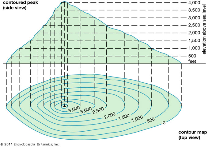
Contour Lines
2. Contour Interval
This is the difference between the height of a contour line and the other. Contour lines are always numbered in meters e.g. 100m, 200m etc.
3. Form Contour
These are broken lines used to represent elevation of a piece of land.
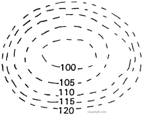
Form Contour
4. Hill Shading
This is a method of shading the height of a place with a single colour.
You are viewing an excerpt of this lesson. Subscribing to the subject will give you access to the following:
- NEW: Download the entire term's content in MS Word document format (1-year plan only)
- The complete lesson note and evaluation questions for this topic
- The complete lessons for the subject and class (First Term, Second Term & Third Term)
- Media-rich, interactive and gamified content
- End-of-lesson objective questions with detailed explanations to force mastery of content
- Simulated termly preparatory examination questions
- Discussion boards on all lessons and subjects
- Guaranteed learning