BASIC CONCEPTS IN MAP READING
CONTENT
- Definition of Map and Map Reading
- Types of Maps
- Uses of Map
- Conventional Symbols
Definition of Map and Map Reading
Maps are the graphical representation of the earth’s surface or part of it on a plane surface such as a sheet of paper drawn to scale. The map of an area shows the features of the area.
Map Reading
Map reading is the ability to recognize the conventional signs and symbols as used on maps and to interpret them.
Types of Maps
Maps can be classified into the following types:
1. Topographical Maps
These are large scale maps which cover relatively small areas, but give detailed information concerning the geographical features of the area that is represented. Such features include relief (which are represented by contour lines), drainage, vegetation and other man-made features like settlements, communication lines, etc. Below is an example of a topographic map.
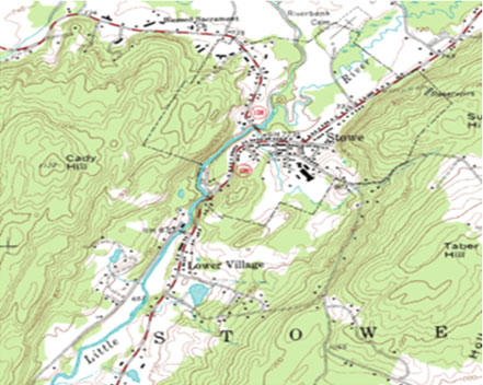
Topographic Map
Topographical maps are also known as Ordinance Survey Maps.
- NEW: Download the entire term's content in MS Word document format (1-year plan only)
- The complete lesson note and evaluation questions for this topic
- The complete lessons for the subject and class (First Term, Second Term & Third Term)
- Media-rich, interactive and gamified content
- End-of-lesson objective questions with detailed explanations to force mastery of content
- Simulated termly preparatory examination questions
- Discussion boards on all lessons and subjects
- Guaranteed learning